 |
|||
|
Page Title:
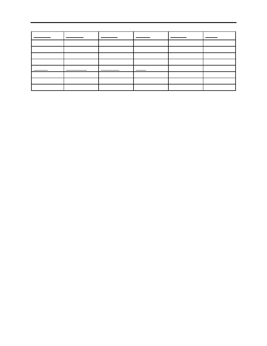
Figure D-1 Table for Local Routes |
|
||
| ||||||||||
|
|  APPENDIX D
LOW-LEVEL AND TACTICAL FORMATION
BIG MAC
LOU ONE
MELLON
SHINER
VR-151
SR-166
TPCH-23B
TPC H-23C
JOG NH 14-12
TPC H-24A
TPC H-24A
TPC H-23C
TPC H-23C
JOG NG 14-2
TPC H-23B
TPC H-23B
JOG NG 14-2
JOG NH 14-11
JOG NH 14-12
JOG NH 14-12
SILVER
AIR FORCE
GO HOME
F4390
TPC H-24A
TPC H-23B
TPC H-23B
TPC H-23C
JOG NH 14-3
TPC H-24A
TPC H-24A
JOG NH 14-11
JOG NH 14-6
J OG NH 14-6
JOG NH 14-12
Figure D-1 Table for Local Routes
Chart Construction. If more than one chart is required, trim the margins from the charts and
tape them together. It is recommended that you tape the backside of the charts. Tape on the
front will interfere with drawing the course lines and other information. Draw the route using an
indelible, black, fine point marker. Once drawn, information can be highlighted using colored
highlighter markers. Use red markers to identify MSA and emergency information on the charts.
1.
Using the information in the Tactical Aircrew Flimsy, Route Way Point Library, locate the
Drop Zone (DZ) and the Initial Point (IP). Using the TAC Plotter, mark these locations IAW
Figure 1-5 of this FTI.
2.
Draw a line connecting the IP and DZ. Do not mark inside the square or the triangle.
3.
Locate the remainder of the turnpoints, including the escape route, using the Way Point
Library and mark IAW Figure 1-5.
4.
Draw a line connecting the first and second points, again not marking inside the circles.
5.
All other turnpoints will be made using the radius-of-turn technique.
a.
Using the TAC Plotter, find the radius-of-turn circle that would approximate 180 kts
at 30. This will vary depending upon which plotter is used and the scale of the chart.
b.
Draw the line from the tangent of the arc to the next turnpoint. Do not draw inside
the circles. Erase any pencil marks used for the radius-of-turn.
c.
Continue this process for all the turnpoints leading to the IP.
d.
Using the proper scale along the TAC Plotter straight edge, draw mileage distance
marks along the left side of each course leg. Mileage numbers start at the total
mileage of each leg and count down to zero from one turnpoint to the next indicating
distance-to-go.
D-2 FLIGHT PREPARATION
|
|
Privacy Statement - Press Release - Copyright Information. - Contact Us |
