 |
|||
|
|
|||
|
|
|||
| ||||||||||
|
|  AVIATION WEATHER
CHAPTER FIVE
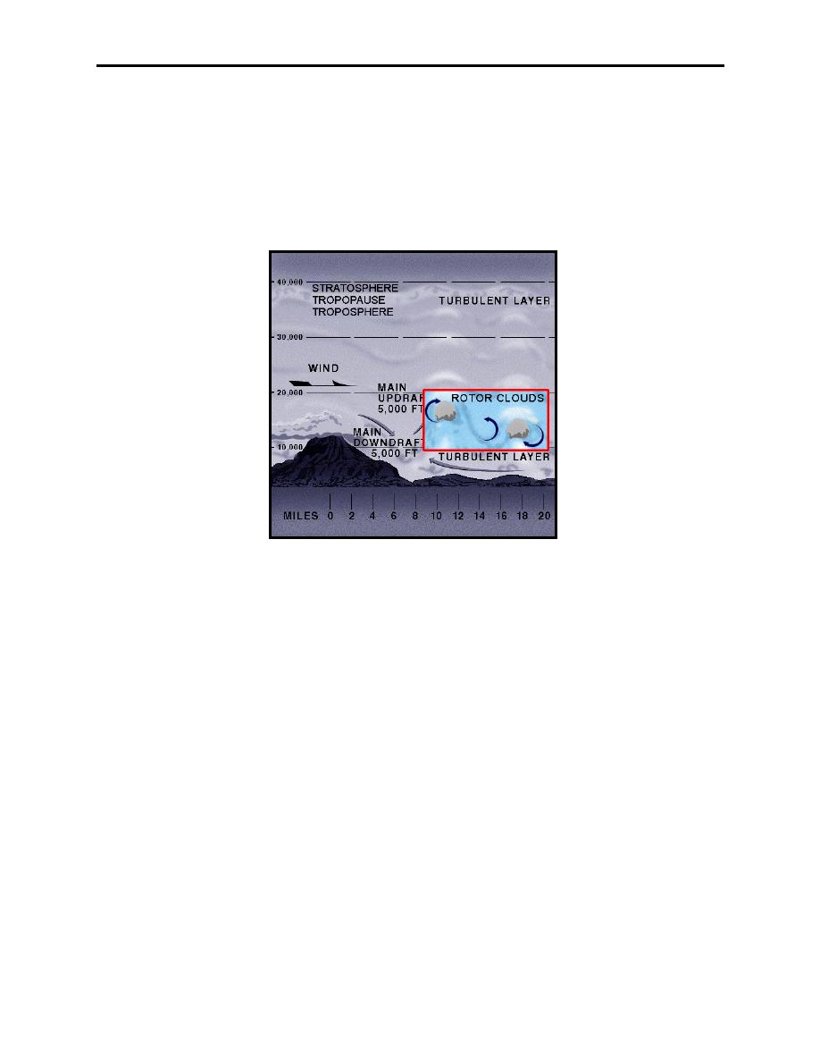
Mountain Wave Turbulence
When strong winds blow approximately perpendicular to a mountain range, the resulting
turbulence can be severe. Associated areas of steady updrafts and downdrafts may extend to
heights from 2 to 20 times the height of the mountain peaks. When the air is stable, large waves
tend to form on the lee side of the mountains and extend up to the lower stratosphere for a
distance of up to 300 miles or more downwind.
Figure 5-4 Mountain Wave Turbulence
These are referred to as standing waves or mountain waves, and may or may not be accompanied
by turbulence (Figure 5-4). Pilots, especially glider pilots, have reported the flow in these waves
is often remarkably smooth. Others have reported severe turbulence.
Even though mountain wave turbulence may be present, when the airflow begins to move up the
windward side of the mountain, it is usually fairly smooth as the orographic lifting imparts the
vertical component to the motion of the air. The wind speed gradually increases, reaching a
maximum near the peak of the mountain. Past the peak, the air naturally flows down the leeward
side, completing one cycle of oscillation and setting up the standing wave pattern of the
mountain wave turbulence. Downwind, perhaps five to ten miles from the peak, the airflow
begins to ascend again, where the rotor or lenticular clouds may appear. Additional waves,
generally less intense than the primary wave, may form farther downwind. Note in Figures 5-4
and 5-5 the mountains are on the left and the wind is flowing from left to right.
While lenticular, cap, and rotor clouds are usually present to warn aircrews of mountain wave
activity, it is possible for wave action to take place when the air is too dry to form clouds,
producing CAT. Still, cloud forms particular to wave action provide the best means of
identifying possible turbulence, aside from weather forecasts and PIREPs. Although the
lenticular clouds in Figure 5-5 are smooth in contour, they may be quite ragged when the airflow
Weather Hazards of Turbulence, Icing, Ceilings, Visibility, and Ash Clouds
5-7
|
|
Privacy Statement - Press Release - Copyright Information. - Contact Us |
