 |
|||
|
|
|||
|
|
|||
| ||||||||||
|
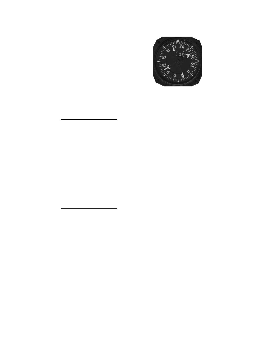
|  13.
You have been cleared to proceed
from your present position (refer to
the BDHI on the right) to the 010
Radial at 55 nm. What is the MC
and distance to be flown?
__________
USE THE JETLOGS AT THE END OF THE CHAPTER AND THE CHART TO
COMPLETE PROBLEMS 14-19.
14.
Situation for Problem 14: Plan to depart from the carrier at 0200Z. Route
of flight: Carrier (28 05'N, 096 25'W) direct MATAGORDA (28 33'N,
096 07W') direct PORT LAVACA (28 39'N, 096 41'W). CA is 2,000 ft,
TAS is 160 kts. Fuel on board is 862 lbs, fuel flow will be 123 pph. The
local altimeter is 30.42", temperature is +25C, and preflight winds are
130/20 kts.
a.
Compute ETA and EFR at Port Lavaca.
AT 0204Z, you are on the 174 radial, 31 DME of the Palacios VORTAC
(28 46'N, 096 18'W).
b.
Plot your position, compute in-flight winds and update ETA and
EFR at Port Lavaca.
15.
Situation for Problem 15: You plan to depart from Huntsville at 1830Z.
Route of flight is Huntsville (30 45'N, 095 35'W) direct Hearne (30 53'N,
096 37'W) direct Giddings Lee (30 10'N, 096 58'W). Planned flight
altitude is 14,000 ft and the TAS is 260 kts. Forecast winds are 020/30
kts with a temperature of -25C. The local altimeter is 29.42". Fuel at
takeoff is 3,500 lbs with a fuel flow of 475pph.
a.
Compute ETA and EFR at Giddings Lee.
At 1836Z, your BDHI shows a bearing to the College Station VORTAC
(30 35'N, 096 25'W) of 247 at 21DME.
b.
Plot your position, compute in-flight winds and update your ETA
and EFR at Giddings Lee.
4.A-161
|
|
Privacy Statement - Press Release - Copyright Information. - Contact Us |